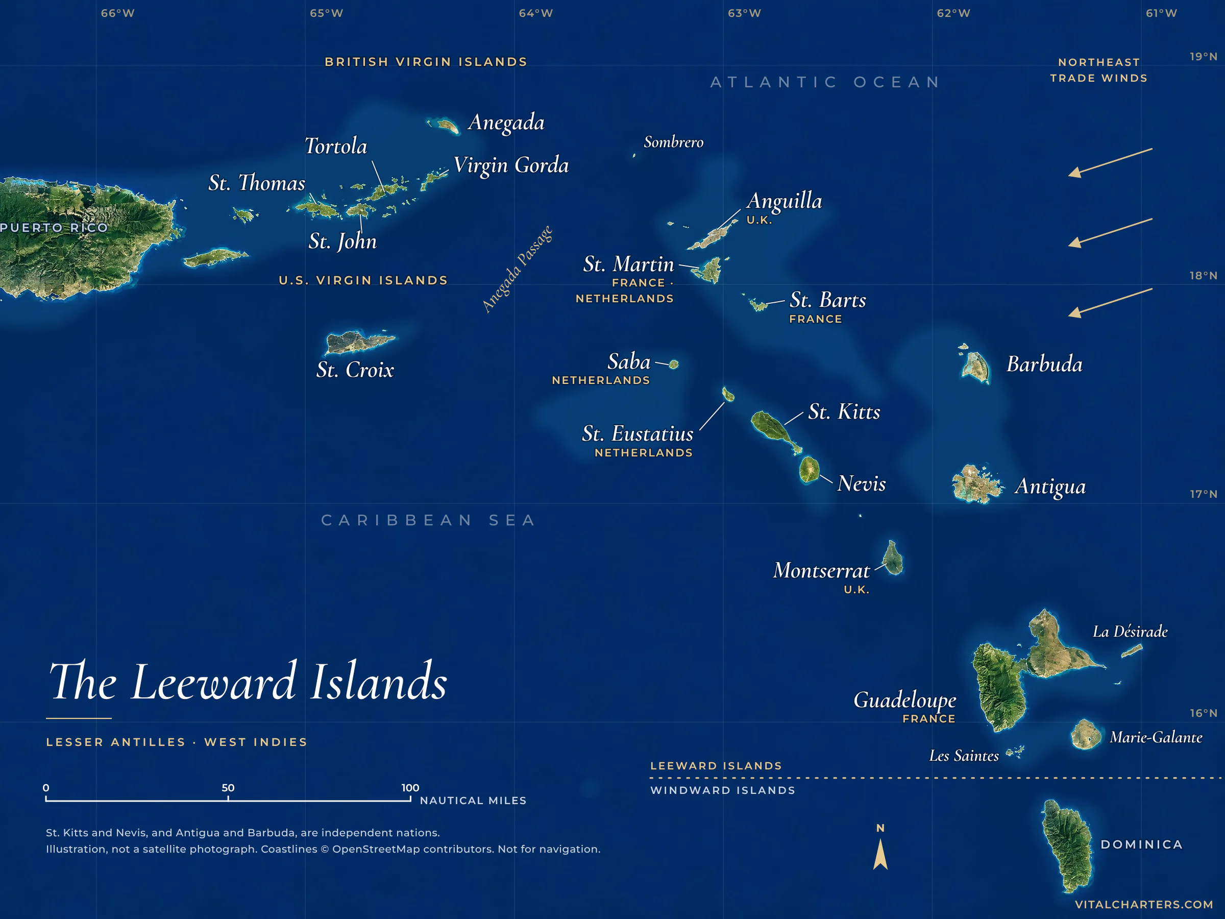
The Leeward Islands Map, Islands and Sailing Guide

Where they are, which islands belong and how they got the name.

Reviewed October 2026

Where are the Leeward Islands?

The Leeward Islands are the northern islands of the Lesser Antilles, in the northeastern Caribbean. They run in an arc from the U.S. and British Virgin Islands, just east of Puerto Rico, southeast through Anguilla, St. Martin, St. Barts, St. Kitts and Nevis, Antigua and Barbuda, and Montserrat to Guadeloupe.

Select an island on the map to open its guide. The map runs from the Virgin Islands to Guadeloupe. Dominica, to the south, is the first of the Windward Islands. Open the full-size map

16° to 19° NThe latitude of the chain, between 61° and 65° west
6 flagsThe United States, the United Kingdom, France, the Netherlands, and two independent nations
7,550 ftThe Anegada Passage splits the chain in two. At more than 7,550 feet it is the deepest channel in the eastern Caribbean
4,813 ftLa Grande Soufrière on Guadeloupe, the highest peak in the Lesser Antilles

The chain is three kinds of island in one. The Virgin Islands, at the northwestern end, sit on the same submerged mountain range as Puerto Rico and the Greater Antilles. Parts of Anguilla, Barbuda, Antigua and eastern Guadeloupe are low coral limestone. From St. Kitts to Montserrat runs a ridge of volcanoes, and the one on Montserrat began erupting in 1995.

The Atlantic lies to the north and east and the Caribbean Sea to the south and west. The trade winds arrive from the Atlantic side, which is the fact that gave the islands their name.

The islands, north to south

Eleven island groups under six flags, in the order they fall along the arc.

IslandFlagMain harbour or townWorth knowing
The Virgin Islands
U.S. Virgin IslandsSt. Thomas, St. John, St. CroixTerritory of the United StatesCharlotte Amalie, St. ThomasU.S. citizens need no passport, and two-thirds of St. John is national park. St. Croix stands apart, well to the south of the other two.
British Virgin IslandsTortola, Virgin Gorda, Jost Van Dyke, AnegadaBritish Overseas TerritoryRoad Town, TortolaThe islands wrap around the Sir Francis Drake Channel, a stretch of protected water. By our count they hold the largest crewed fleet of any Caribbean cruising ground.
The northern Leewards
AnguillaBritish Overseas TerritoryRoad Bay. The capital is The Valley.Low, quiet and edged with beaches. Sandy Island and the Prickly Pear Cays lie just offshore.
St. MartinSaint-Martin and Sint MaartenFrance in the north, the Kingdom of the Netherlands in the southSimpson Bay and Philipsburg on the Dutch side, Marigot on the French sideOne island, two countries and an open border. Most crewed charters in these islands board on the Dutch side, around Simpson Bay Lagoon.
St. BartsSaint-BarthélemyFranceGustaviaGustavia's harbour fills with yachts through the winter. Anse de Colombier, at the island's northwestern tip, is the quiet anchorage.
SabaThe NetherlandsFort Bay. The capital is The Bottom.A single steep volcano rising straight out of the sea. Its summit, Mount Scenery, is the highest point in the Kingdom of the Netherlands.
St. EustatiusStatiaThe NetherlandsOranjestadSmall and little visited, beneath a dormant volcano called the Quill. In the 18th century it was one of the busiest trading ports in the Caribbean.
The southern Leewards
St. Kitts and NevisIndependent nationBasseterre on St. Kitts, Charlestown on NevisTwo volcanic islands divided by a channel called The Narrows. Brimstone Hill Fortress on St. Kitts is a UNESCO World Heritage Site.
Antigua and BarbudaIndependent nationSt. John's. Yachts use English Harbour and Falmouth Harbour.English Harbour holds Nelson's Dockyard, a Georgian naval yard and UNESCO World Heritage Site. Barbuda, to the north, is flat, sandy and nearly empty.
MontserratBritish Overseas TerritoryLittle BayThe Soufrière Hills volcano began erupting in 1995 and buried the old capital, Plymouth. The southern part of the island remains an exclusion zone.
GuadeloupeWith Les Saintes, Marie-Galante and La DésiradeFrancePointe-à-Pitre. The capital is Basse-Terre.Two islands separated only by a narrow channel: mountainous Basse-Terre and low Grande-Terre. Together they are the largest island in the Leeward chain, and its southern end.

Dominica, immediately south of Guadeloupe, was administered as one of the Leeward Islands until 1940. It is now counted with the Windward Islands.

Why they are called the Leeward Islands

The name comes from the age of sail. Leeward means downwind, the direction the wind is blowing toward. Windward is the opposite, the direction the wind is coming from.

In the eastern Caribbean the trade winds blow steadily from the east and northeast. Ships arriving on those winds from across the Atlantic usually made their first landfall around Dominica and Martinique. Those islands, the furthest upwind, became the Windward Islands. Everything to the north and west of them lay downwind, to leeward.

Spanish navigators drew the line somewhere else. They called Puerto Rico and the islands west of it Sotavento, leeward, and the islands to the south and east Barlovento, windward. It was the British who gave the name its modern sense. They first applied it to Antigua, Montserrat and the islands north of them, and from 1671 governed those islands as a single colony called the Leeward Islands. In time the name came to cover every island north of Martinique.

  1. 1493Columbus, on his second voyage, sights Dominica on Sunday 3 November and sails on. The island later marks the line between the two groups.
  2. 1671England joins its northern islands into one colony and names it the Leeward Islands.
  3. 1940Dominica is transferred from the Leeward Islands to the Windward Islands, which sets the line where it runs today.

Leeward Islands vs. Windward Islands

Together they form the main arc of the Lesser Antilles. The Leewards are the northern group and the Windwards the southern.

The northern group

Leeward Islands

Where
The northeastern Caribbean, between 16° and 19° north.
Islands
The U.S. and British Virgin Islands, Anguilla, St. Martin, St. Barts, Saba, St. Eustatius, St. Kitts and Nevis, Antigua and Barbuda, Montserrat and Guadeloupe.
Climate
Drier than the islands to the south.
Sailing
Short, protected hops in the Virgin Islands. Open-water channel crossings from St. Martin south.

The southern group

Windward Islands

Where
The southeastern Caribbean, between 12° and 16° north.
Islands
Dominica, Martinique, St. Lucia, St. Vincent, the Grenadines and Grenada. Barbados and Trinidad and Tobago are often grouped with them.
Climate
Wetter. Rainfall increases toward the south, and the eastern sides of the islands catch the most.
Sailing
Spirited open-water sailing between islands, with calm, protected anchorages at the end of each leg.
Where we charter
The Grenadines.

The line between them runs through the channel that separates Guadeloupe from Dominica.

What leeward means on the water

The word is still in daily use on every yacht. You will hear your crew say it on the first day.

Toward the wind

Windward

The side the wind reaches first. The windward coast of an island takes the breeze and the ocean swell, so it is the rougher side.

Away from the wind

Leeward

The downwind side. On land most people say LEE-ward. Sailors traditionally say LOO-erd, and both are correct.

The sheltered patch

In the lee

The calmer wind and flatter water behind an island or a headland. It is what a crew looks for when choosing where to anchor.

This is the part that matters on charter. With the trade winds arriving from the east, the calm water is usually on an island's western and southern shores, and that is where your captain will anchor for the night. The channels between islands are open to the wind and the swell, which is why a crossing feels livelier than the hours on either side of it.

The rule of the road. The same two words decide who gives way. Under the international collision regulations, when two sailing vessels meet with the wind on the same side, the vessel to windward keeps out of the way of the vessel to leeward. When the wind is on different sides, the vessel with the wind on her port side gives way.

Chartering the Leeward Islands

On a map the Leewards are one chain. On charter they are two worlds, with the Anegada Passage between them.

The Anegada Passage, the deepest channel in the eastern Caribbean, separates the Virgin Islands from Anguilla, St. Martin and everything beyond. It is the reason charter listings treat the two halves separately: the Virgin Islands appear under their own names, and "the Leeward Islands" usually means the islands from Anguilla and St. Martin south.

That leaves three cruising grounds to choose between. The figures below are from our own fleet data.

Cruising groundCrewed yachtsMedian week, all inThe sailing
British Virgin IslandsPeak December to May385
80.0% catamarans. Median length 59 ft.
$37,000
$1,257 per stateroom, per night.
Protected waters, short island hops and easy line-of-sight navigation.
See BVI yachts
U.S. Virgin IslandsPeak December to May256
75.8% catamarans. Median length 59 ft.
$36,821
$1,214 per stateroom, per night.
Short, protected island hops with sheltered bays and abundant moorings.
See USVI yachts
St. Martin, St. Barts and AnguillaPeak December to April228
63.6% catamarans. Median length 67 ft.
$48,000
$1,629 per stateroom, per night.
Open-ocean channel crossings mixed with marina stays and protected bays.
See Leeward Islands yachts

Vital Charters fleet data, compiled September 2026 from live crewed charter availability and booking records. The median week is base rate plus APA for seven nights, across all group sizes. The fleet pages show today's listings, so their counts differ.

When to go

The dry, breezy peak season runs from December to April around St. Martin and into May in the Virgin Islands. The Atlantic hurricane season runs from 1 June to 30 November.

Crossing borders

Each island group is its own jurisdiction. A week out of St. Martin takes in French, Dutch and British waters, and the yacht clears in and out at St. Barts and Anguilla. Your crew handles the paperwork.

How far apart

St. Barts lies roughly 17 nautical miles southeast of St. Martin, and Anguilla roughly 13 nautical miles to the north. Both are a morning's sail rather than a passage.

Which yacht

Catamarans are 80.0% of the crewed fleet in the British Virgin Islands and 63.6% around St. Martin. The open crossings there leave more room for monohulls and motor yachts, and the yachts run larger.

Getting there

Fly to Princess Juliana (SXM) for St. Martin, to Cyril E. King (STT) on St. Thomas for the U.S. Virgin Islands, and to Beef Island (EIS) or St. Thomas for the British Virgin Islands. Our guide covers getting from St. Thomas to Tortola.

Leeward Islands FAQs

What are the Leeward Islands?

The Leeward Islands are the northern group of the Lesser Antilles, in the northeastern Caribbean. They form an arc from the Virgin Islands, just east of Puerto Rico, southeast to Guadeloupe. The southern group of the Lesser Antilles, from Dominica to Grenada, is called the Windward Islands.

Which islands are in the Leeward Islands?

From north to south: the U.S. Virgin Islands, the British Virgin Islands, Anguilla, St. Martin, St. Barts, Saba, St. Eustatius, St. Kitts and Nevis, Antigua and Barbuda, Montserrat and Guadeloupe.

Why are they called the Leeward Islands?

Leeward means downwind. Trade winds blow across the eastern Caribbean from the east and northeast, and sailing ships arriving on them from across the Atlantic usually made their first landfall around Dominica and Martinique. The islands north and west of that landfall lay downwind of it, so they became the Leeward Islands.

What is the difference between the Leeward Islands and the Windward Islands?

They are the two groups that form the main arc of the Lesser Antilles. The Leeward Islands are the northern group, from the Virgin Islands to Guadeloupe. The Windward Islands are the southern group: Dominica, Martinique, St. Lucia, St. Vincent, the Grenadines and Grenada. The Leewards are drier, and the Windwards receive more rain.

Are the Virgin Islands part of the Leeward Islands?

Yes. The U.S. and British Virgin Islands are the northwestern end of the Leeward Islands, although geologically they belong with Puerto Rico and the Greater Antilles. In yacht charter listings they are usually treated as cruising grounds of their own.

Is Dominica a Leeward Island or a Windward Island?

Dominica is counted as a Windward Island today. Britain administered it as part of the Leeward Islands until 1940, when it was transferred to the Windward Islands.

Are Aruba, Bonaire and Curaçao Leeward Islands?

Not in English. Those islands, off the coast of Venezuela, are called the Leeward Antilles. In Dutch, French and Spanish, however, the leeward name traditionally belongs to them, and the whole chain from the Virgin Islands to Trinidad is called windward.

How do you pronounce leeward?

Both ways are correct. On land most people say LEE-ward. Sailors traditionally say LOO-erd.

When is the best time to sail the Leeward Islands?

December to April is the dry, breezy peak season, and it runs into May in the Virgin Islands. The shoulder months, May and June around St. Martin and June and November in the Virgin Islands, are quieter, with softer rates. The Atlantic hurricane season runs from 1 June to 30 November.

Can I charter a yacht in the Leeward Islands?

Yes. Crewed yachts charter by the week in three Leeward cruising grounds: the British Virgin Islands, the U.S. Virgin Islands, and St. Martin, St. Barts and Anguilla. Vital Charters counted 385, 256 and 228 crewed yachts in those grounds in September 2026.

Sources, reviewed October 2026

Choose your side of the passage.

Tell us your dates and who is coming. We will tell you which of the three grounds suits your week, and which yachts are free.

Preferred Contact Method
Select one or more, and we'll reach out the way you prefer.
Or

Call us directly at 1 (407) 922-9696

24-Hour Response No Fees, No Obligation